
Global Patterns Affecting Hurricanes
There are several global atmospheric patterns which may influence tropical cyclone development. The most famous global pattern impacting hurricane development is El Niño/La Niña. ElNiño refers to an unusual warming of the sea surface temperatures in the Central Pacific, but it can have impacts on hurricane formation across the globe. The El Niño Southern Oscillation, or ENSO, refers to the pattern of warmer or cooler sea surface temperatures over the Central Pacific. During ENSO neutral years, the normal pattern of warm sea surface temperatures over the Western Pacific and cool sea surface temperatures over the Eastern Pacific is observed. During LaNiña years, this pattern is amplified such that cooler waters are observed stretching into the Central Pacific and strong trade winds result in increased convection over the Western Pacific.

The warmer sea surface temperatures over the Central Pacific during ElNiño often result in a pronounced subtropical jet stream, which extends over the southern United States. This subtropical jet stream introduces increased wind shear over the southeast United States and the Gulf of Mexico, which can often disrupt tropical cyclone development in the Atlantic basin. In contrast, during LaNiña years, the subtropical jet is diminished, resulting in relatively warm temperatures over the southeast United States, which often helps tropical cyclone development in the Atlantic basin. As a result, years with a strong LaNiña tend to be associated with more active hurricane seasons in the Atlantic basin.
Madden-Julian Oscillation (MJO)
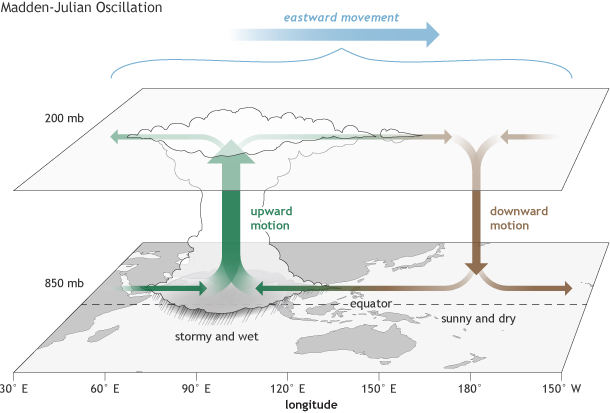
Another major influence on the tropical atmosphere is the Madden-Julian Oscillation, or MJO. This is a one to two month oscillation, which results in large areas of increases and decreases in tropical rainfall and convection. The MJO is a pattern which propagates eastward around the globe and promotes deep convection in the tropics depending on the location of the oscillation. The MJO results in increased upper-level divergence, which is more supportive of the formation of deep convection, as well as upper-level convergence, where convection is suppressed. The portion of the MJO with increased upper-level divergence also enhances the development of tropical cyclones. The MJO can be used to broadly forecast the likelihood of tropical cyclone development in the Atlantic basin over a two to three week period. Because the MJO travels from west to east, increased convection can be observed over the Pacific Ocean prior to the MJO resulting in increased convection over the Atlantic Ocean.
Atlantic Multidecadal Oscillation (AMO)
The Atlantic Multidecadal Oscillation, or AMO, refers to the variability of sea surface temperatures in the Atlantic Ocean, which occurs over multiple decades. Periods of warm sea surface temperatures favor increased tropical cyclone activity in the Atlantic basin. Currently, the AMO is in a period of relatively warm sea surface temperatures in the North Atlantic basin, which is resulting in increased tropical cyclone activity.

North Atlantic Oscillation (NAO)
The North Atlantic Oscillation, or NAO, is a pattern of increased and decreased atmospheric sea level pressure over the North Atlantic Ocean. There are two phases of the NAO: either positive or negative. A positive NAO results in a strong high pressure system in the mid-latitudes of the Atlantic Ocean, often referred to as the Azores High, as well as a strong low pressure system in the upper mid-latitudes of the Atlantic Ocean, often referred to as the Icelandic Low. A negative NAO results in both a weaker Azores High and a weaker Icelandic Low. In other words, a negative NAO represents a weaker pressure gradient across the North Atlantic Ocean.
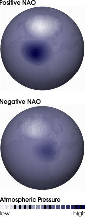
The NAO can influence the track of tropical cyclones in the Atlantic basin because a stronger Azores High typically results in stronger trade winds over the subtropics. During the positive NAO phase, these trade winds steer tropical cyclones toward the west, which often results in tropical cyclone tracks staying farther south than they would during a negative NAO phase.
Velocity Potential Anomaly
The Velocity Potential Anomaly, often referred to as the VP200a, is a derived quantity based on the 200 millibar winds which calculates the amount of upper-level divergence. Regions of negative VP200a favor enhanced deep convection in the atmosphere. Significantly negative VP200a may indicate a favored region for tropical cyclone development if other necessary ingredients are present such as warm sea surface temperatures. Positive VP200a represents upper-level convergence, which results in sinking air and the suppression of thunderstorms. VP200a is often assessed with ensemble model means to capture long-term variability in atmospheric models.