
Phase Space and Extratropical Transition
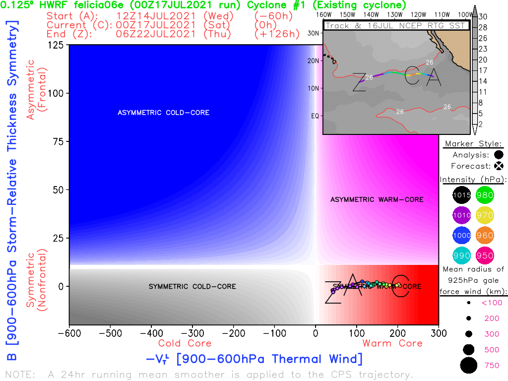
Healthy tropical cyclones exhibit both a warm core, where temperatures and therefore atmospheric thickness are greater towards the center of low pressure, and thermal symmetry, where that warm core exists on all sides of the storm. If fronts were to develop as seen in mid-latitude cyclones, then the low pressure system would begin to lose its tropical characteristics and would become thermally asymmetric. The thermal structure of a low pressure system can be understood by examining the strength of the warm core and the thermal symmetry. Diagrams which show warm core vs. cold core and symmetric vs. asymmetric thermal structure are referred to as phase space diagrams. The above image is an example of a phase space diagram from a healthy tropical cyclone. Following the tropical cyclone’s life cycle from A to Z in the diagram will show a symmetric, strengthening hurricane as the intensity of the warm core increases, and then eventual dissipation as the strength of the warm core weakens to almost zero.
Extratropical Transition
In contrast to tropical cyclones, mid-latitude cyclones exhibit a cold core thermal structure with strong asymmetry as cold and warm fronts develop. The process of a tropical cyclone changing into a mid-latitude cyclone is referred to as extratropical transition. During extratropical transition, fronts will start to develop as tropical cyclones move into the mid-latitudes, which have strong temperature gradients with cooler temperatures toward the poles. Extratropical transition changes the thermal structure and the threats associated with a low pressure system. While very strong sustained winds as seen in hurricanes may not persist during extratropical transition, the expected severe weather threats from mid-latitude cyclones, such as damaging wind gusts, tornadoes, and heavy rainfall, will still be possible. The most prominent example of a hurricane undergoing extratropical transition and still being very impactful is Hurricane Sandy from 2012, which caused extensive damage to the Northeast United States even as it was losing its warm core characteristics.
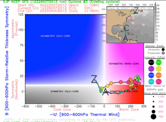
The above phase space diagram shows the extratropical transition of a tropical cyclone, where it starts off as a symmetric warm core system and then loses its symmetric qualities as fronts develop around the low pressure center. While there are still strong winds observed with the cyclone as it has asymmetric warm core characteristics, the strength of the winds begins to dissipate as the thermal structure becomes cold core. The map in the top right corner of the phase space diagram shows that this extratropical transition was occurring as the cyclone moved northward into the mid-latitudes of the Northern Hemisphere.