
Supercell Dynamics
Supercells are discrete, powerful thunderstorms which almost always result in severe weather. They are characterized by a strong, rotating updraft, which forms a mid-level mesocyclone and can lead to all type of severe weather, including damaging winds, large hail, and tornadoes. Below is an annotated picture of a supercell, which shows the rotating updraft in red, and below this updraft is the most common location for tornadoes to form.

The above image shows an aerial view of what supercells look like in the atmosphere. This image shows the four ingredients for severe thunderstorm forecasting, with shear indicated by the anvil (the blue arrow), lift indicated by the converging low-level winds, instability indicated by the strong updraft, and moisture indicated by the abundance of clouds.
In addition to the strong, rotating updraft, supercells create a forward-flank and a rear-flank downdraft. These downdrafts, especially the rear-flank downdraft, can be critical for the formation of severe weather and tornadoes. In the image below, the rear-flank downdraft is denoted by the letters RFD, and it adds to the surface convergence, which strengthens the updraft. Sometimes the RFD produces the strongest surface winds in the supercell and can be a danger to people observing this weather in action.

In the above image, the forward-flank downdraft is denoted by the letters FFD. This area is often where a lot of the heavy rain and large hail is precipitated. The red colors in this diagram denote the typical formation of radar reflectivity values. Note the distinctive “hook echo” shape just north of the RFD. This hook echo is curling around the updraft and is oftentimes the location of the tornado. The below image shows a side view of a mature supercell thunderstorm with the same features.
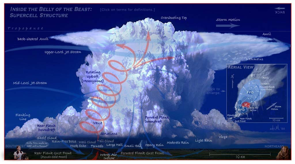
In this image, the rotating updraft or mesocyclone is denoted in red, with the rear-flank downdraft on the left side of the image and the forward-flank downdraft on the right. Note how the tornado is near the base of the updraft, and surface convergence is aided by winds from the rear-flank downdraft. Also, almost all of the precipitation is occurring near the base of the forward-flank downdraft. The anvil cloud in the top-right portion of this image stretches in the direction of the upper level jet stream and indicates roughly the motion of the storm. The forward-flank downdraft is on the forward side of the storm in the direction the storm is moving, and the rear-flank downdraft is on the back side of the storm behind the direction of motion.