
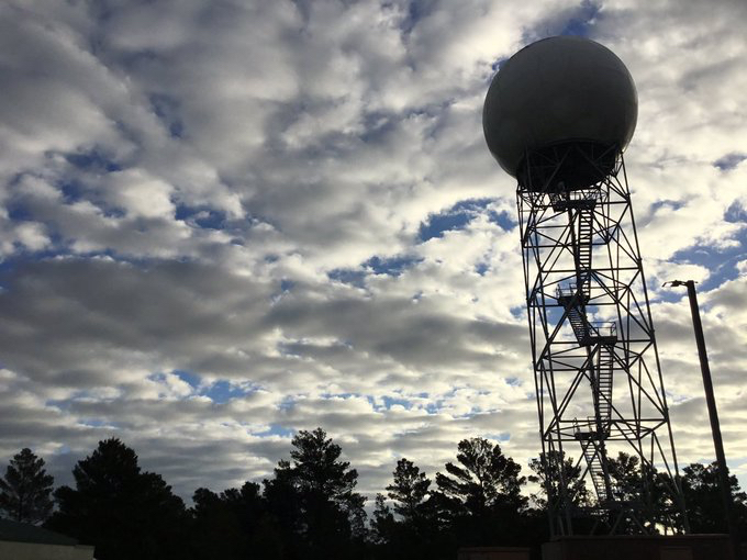
How Does Radar Work?
Radar is the primary instrument meteorologists use to observe most of the weather systems across the world. A radar works by sending out a beam of radiation in all directions and listening for what radiation gets bounced back to the radar by things like rain, hail, clouds, etc. The radar beam is sent at a slight elevation above ground level so that farther away from the radar, the greater the height of the beam is. This elevation has the advantage of not bouncing off of objects like tall buildings and wind turbines, but the main disadvantage is that at greater distances from the radar, the lowest beam can still be several thousand feet above ground level.
What Radars Measure
There are two main variables which are being measured by radar: one is how much power of the beam is being returned by things like rain or other things in the path of the beam, and the second is how fast those things are moving. The amount of power returning to the radar is commonly expressed as reflectivity. This is what you often see on radar maps from broadcast meteorologists, the National Weather Service, The Weather Channel, etc. For example, the more rain and hail in a cloud that is in the path of the beam, the higher the reflectivity will be on the radar map. Thunderstorms which are producing high reflectivity values as seen on the radar are often very intense and may be creating large, solid objects like hail. How fast objects are moving is measured as velocity by the radar beam. The wave of the power returned to the radar will be slightly displaced, resulting in a phase shift of the radar beam. That phase shift (or “Doppler effect”) can be compared to the original radiation sent out by the radar to determine the velocity of the object that was intercepted by the radar beam. This method for measuring velocity is why radar is often referred to as Doppler radar. One big caveat about this velocity is that it is only measured in the direction of the radar beam itself. For example, if an object was traveling at 50 mph exactly perpendicular to the radar beam, the radar would interpret it as having a velocity of zero because it’s not moving up or down in the direction of the radar beam, i.e. it’s not getting closer to or farther away from the radar.

The radar can also measure many other variables through a combination of analyzing the patterns from reflectivity and velocity. For example, one of the variables that the radar is able to measure is called correlation coefficient. Correlation coefficient is a measure of how uniform the features the radar is measuring are. If correlation coefficient is high, that means that all of the different signals being returned to the radar are very similar to each other; if the correlation coefficient is low, then the different signals being returned to the radar are very different from each other. High correlation coefficient would be expected in a weak thunderstorm, which is mostly just rain. However, if a thunderstorm becomes strong enough, it may start producing hailstones, which would be moving at different speeds and in different directions than the rain droplets, and that may start to cause a drop in correlation coefficient. In fact, very low correlation coefficient that is associated with a storm that may be producing a tornado can be used to identify a possible path of debris caused by the tornado because that debris would be moving in a wildly different way than the rain and the hail around it.
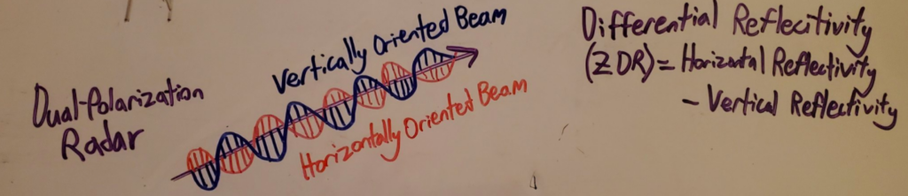
Dual-Polarization
Between 2000 and 2010, the National Weather Service upgraded almost all of their radars to have dual-polarization capabilities. Dual-polarization means that the radar is actually sending out two radar beams at any time, one which is oriented horizontally, and one which is oriented vertically. This allows meteorologists to tell the shape of objects being intercepted by the radar beam. This is important for identifying what type of hydrometeor (such as rain, hail, sleet, snow) is occurring along the radar beam. For example, when raindrops fall, they take the shape of discs, which are larger in the horizontal direction than the vertical direction. This means that if the radar is detecting raindrops, it would be expected to return more power in the horizontal direction than in the vertical direction. However, if a thunderstorm becomes strong enough to produce hailstones, even if the hailstones are very spiky, the hailstones will be tumbling up and down in the updrafts and downdrafts of a thunderstorm, and will appear to the radar to be circular (i.e. returning equal power in the horizontal and vertical directions).
Radar Scanning Patterns
The radars operated by the National Weather Service have specific scanning patterns called Volume Coverage Patterns (VCPs). These VCPs allow meteorologists to better detect different weather phenomena by changing how quickly and with what resolution the radar is sampling the atmosphere. One of the main variables is the elevation angle of the radar beam. The lowest beam is always at an angle of 0.5 degrees above ground level, but there are also several higher elevation angle scans, which better sample the upper parts of the atmosphere. There are also VCPs specifically designed for “clear weather” days, commonly called Clear Air Mode. These Clear Air Mode VCPs have higher sensitivity to smaller weather phenomena like cloud droplets and dust. If you would like to learn more about VCPs, visit https://www.weather.gov/jetstream/vcp_max.