
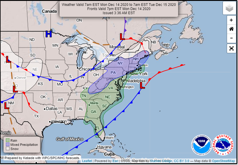
What Patterns Cause Winter Weather?
Winter weather is much more difficult to forecast than severe weather. It is not quite as simple as the ingredients-based approach that severe weather has. Things like the orientation of the cold front and the warm front and what path the surface low takes can make a huge difference in how much snow falls in a particular area. The image below shows a typical winter weather pattern for the northeast United States – a surface low pressure system along the East Coast, with a cold front stretching down into the Deep South, and a warm front affecting New England. Because snow forms when temperatures are below freezing, the location where the temperatures switch from above 32 degrees Fahrenheit to below 32 degrees Fahrenheit is difficult to forecast ahead of the event.
The Jet Stream
A particular orientation of the jet stream is very important for the formation of winter weather events in the central and eastern United States. Typically, a large dip in the jet stream (aka a “trough”) is needed to bring cold air further south. In addition, this trough in the jet stream allows surface low pressure systems to form. These surface low pressures with their associated cold and warm fronts are very important to have the lifting mechanism for precipitation.

The above image is the analyzed upper-level winds that will lead to the winter weather event in the top image. A trough in the jet stream is clearly visible above the central United States. This trough will help develop the surface low, which will lead to snow and ice in the northeast United States.
Surface Low Pressure
The location and track of the developing surface low pressure system is critical for forecasting where winter weather will occur. Just a slight difference in the timing or track of the low pressure minimum could mean the difference between getting feet of snow or getting no snow at all for a particular location. This is what gives meteorologists headaches when forecasting winter weather events. Many weather models will try to predict a possible outcome of where the surface low pressure will form and track, but rarely do they ever get it right on the nose. This is why most winter weather forecasts are more probabilistic (e.g. you might get 6-12 inches of snow), rather than deterministic, meaning there is one forecasted outcome (e.g. the high temperature today is 75 degrees).